Ghana recently concluded its presidential and parliamentary elections for the 2025–2029 term, an event that has once again reaffirmed the country’s commitment to democracy. As Ghanaians, we take pride in our ability to maintain calm and peace during elections, a rarity in many parts of the world. Our democracy continues to serve as a beacon of hope for Africa, drawing lessons from advanced democracies such as the United States and the United Kingdom.
Congratulations to the National Democratic Congress for a resounding victory. I wish you all the best. Awesome teamwork and congratulations to the NPP for supporting and endorsing factors on maintaining the peace of Ghana.
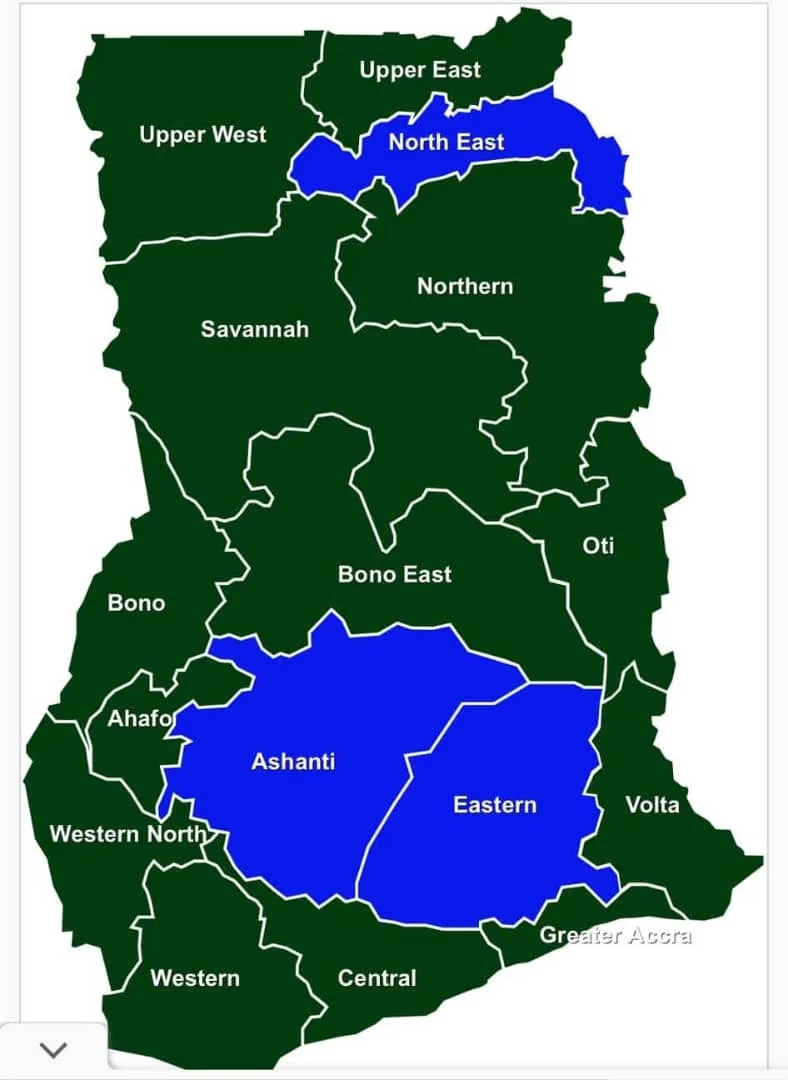
However, a disconcerting trend threatens to erode this unity: the misrepresentation of our electoral outcomes through misleading regional maps akin to the American “red states vs. blue states” dichotomy. I saw a green region vs. blue region map that is disheartening and raises my concern.
Ghana’s Democracy: A Unique Identity
Unlike the United States, where a winner-takes-all electoral college system determines the presidency, Ghana operates a direct popular vote system. *Every vote counts equally,* and parliamentary seats are won constituency by constituency, not by amalgamated regional majorities. Ghana is also *not a bipartisan nation.*
Although the New Patriotic Party (NPP) and the National Democratic Congress (NDC) dominate the political landscape, smaller parties and independent candidates contribute to the richness of our democracy.
Yet, the adoption of American-style electoral maps *distorts this reality.* These maps, which assign an entire region the color of the party that wins the majority of its votes, *misrepresent the political diversity* within our regions. For instance, while the NPP secured a majority of seats in the Ashanti Region, this does not mean the region is monolithic in its support. Many constituents voted for the NDC or other parties, yet their voices are visually erased in such depictions.
The Danger of Misleading Maps
This practice poses significant psychological risks. Imagine being an NDC voter in the Ashanti Region or an NPP supporter in the Volta Region—such maps, render your vote invisible. Worse, the maps perpetuate a false narrative that Ghana’s electoral outcomes are divided along tribal lines.
Historically, this mapping trend has existed for years. In 2008, similar maps portrayed Ghana as two regions against the rest—a false and divisive image. While the percentages in that election were close (NDC’s John Atta Mills won with 50.23% against NPP’s Nana Akufo-Addo with 49.77%), the visual representation suggested a stark division.
This visual oversimplification has profound implications. It suggests that some regions’ votes wield disproportionate power, creating the perception that certain tribes or areas can override the collective will of the rest of the country. Such narratives risk deepening tribal sentiments and fostering unhealthy competition among regions.
Lessons from the American Experience
In the United States, the “red state vs. blue state” phenomenon has fueled polarization. The visual simplicity of maps, where entire states are assigned one party’s color, masks the complexity of voter preferences. It has also contributed to racial and ideological divides. Hate groups and extremist movements have exploited these visuals to amplify their narratives, resulting in increased societal tensions.
Ghana can not afford to replicate these mistakes. The strength of our democracy lies in its inclusivity and its ability to reflect the diversity of our people.
A Call for Action
We must rethink how we represent electoral outcomes. Developers of these maps should strive for accuracy and fairness, highlighting the diversity within regions rather than painting them with a single brushstroke. A proportional representation system for maps could better reflect the true distribution of votes, showcasing the coexistence of different political ideologies within each region. There is no need to use the colors of the two parties. Perhaps a percentage graph or just the plain numbers may be a better option; for we are neither green nor blue. We are Ghanaians, and we choose who to vote for at any point we want.
As citizens, we must also reject tribal politics. Ghana’s motto, freedom and justice, calls for unity and fairness, not division. Politicians, media houses, and civil society organizations have a responsibility to promote narratives that unite rather than divide us.
Conclusion
The power of visuals is undeniable, and the maps we create today shape the perceptions and attitudes of future generations. Let us not plant seeds of division through inaccurate and divisive electoral depictions. Ghana’s democracy is a model for Africa and the world—not because it mimics other systems, but because it thrives on the principles of inclusivity and unity. Together, we can ensure that every Ghanaian, no matter the political view (green, red, blue, yellow, black, etc.) regardless of region or tribe, feels seen and valued in our democratic journey. There is a good reason why our flag has more than two colors.
Let us rise above the blue and green (red/blue) and celebrate the vibrant mosaic that is Ghana.
I am a proud Ghanaian lady and mother, committed to raising my generation in legacy that is above “polytricks”.
By:
Winnie Van Oak
(+233244516463)
Please subscribe to our YouTube channel: https://youtube.com/
Source: TheDailyTrustGh.com


